Key Agricultural Drones Functions for Precision Agriculture
Welcome to My Blog!
Before we dive into the content, I’d love for you to join me on my social media platforms where I share more insights, engage with the community, and post updates. Here’s how you can connect with me:
Facebook:https://www.facebook.com/profile.php?id=61557298070472
Now, let’s get started on our journey together. I hope you find the content here insightful, engaging, and valuable.
Table of Contents
Introduction

In recent years, agricultural drones have emerged as a revolutionary tool in the field of precision agriculture. The agricultural drones function effectively to address the growing challenges of climate change, population growth, and the need for sustainable practices. These advanced aerial systems offer innovative solutions that optimize crop production and enhance efficiency. By leveraging technology, agricultural drones can collect valuable data, monitor crop health, and improve overall farm management. This blog will explore the key functions of agricultural drones, their applications in precision agriculture, and the benefits they provide to farmers.
The Role of Agricultural Drones in Precision Agriculture
Precision agriculture is a farming management system that uses technology to collect, process, and analyze data, and then uses that information to apply inputs such as fertilizers and pesticides with site-specific variable rates at the right location and time. Agricultural drones play a crucial role in precision agriculture by providing the following key functions:
Data Acquisition:
- Multispectral Imaging: Drones equipped with multispectral sensors can capture images in various wavelengths of light, providing insights into plant health, nutrient deficiencies, and stress.
- Thermal Imaging: Thermal sensors can detect temperature variations in crops, helping to identify areas of heat stress or disease.
- LiDAR: Light Detection and Ranging (LiDAR) sensors can create detailed 3D maps of fields, providing information on topography, elevation, and vegetation density.
Mapping and Surveying:
- Field Boundary Mapping: Drones can accurately map field boundaries, helping farmers to optimize their operations and reduce overlap.
- Topographic Mapping: By creating high-resolution topographic maps, farmers can identify areas with varying soil types, slopes, and drainage patterns.
- Digital Elevation Models (DEMs): DEMs can be used to plan irrigation and drainage systems, as well as identify areas prone to erosion.
Crop Monitoring:
- Early Disease Detection: Drones can detect early signs of disease or pest infestations, allowing farmers to take timely action to prevent outbreaks.
- Nutrient Deficiency Mapping: By analyzing spectral data, farmers can identify areas with nutrient deficiencies and apply fertilizers more precisely.
- Weed Detection and Control: Drones can help identify and map weed infestations, enabling targeted weed control measures.
Variable Rate Application:
- Precision Fertilization: By analyzing soil and crop data, farmers can apply fertilizers at the optimal rate for each specific area, reducing input costs and environmental impact.
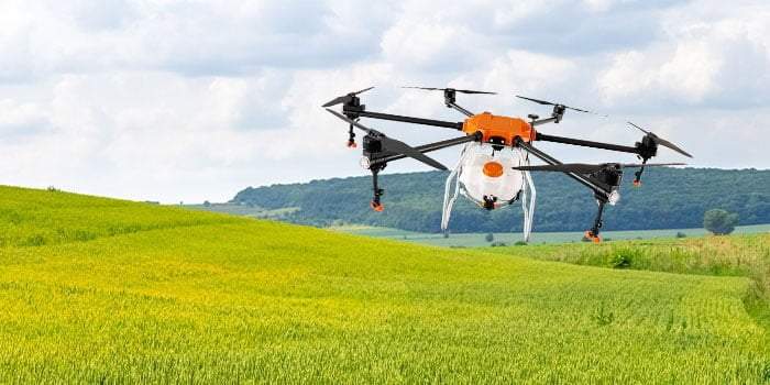
- Precision Pesticide Application: Drones can be equipped with sprayers to apply pesticides and herbicides with high precision, minimizing off-target drift and reducing chemical usage.
- Seed Sowing: Drones can be used to sow seeds at precise intervals, ensuring optimal plant spacing and maximizing yield potential.
Key Components of an Agricultural Drone
- Payload: The payload of an agricultural drone typically includes a variety of sensors, such as multispectral cameras, RGB cameras, thermal sensors, and LiDAR sensors.
- Flight Controller: The flight controller is the “brain” of the drone, responsible for controlling its flight path, altitude, and orientation.
- GPS: The Global Positioning System (GPS) allows the drone to accurately navigate and follow pre-programmed flight paths.
- Battery: The battery life of the drone determines its flight time and the amount of data it can collect.
- Communication System: The communication system allows the drone to transmit data to a ground control station.
Benefits of Using Agricultural Drones
- Increased Efficiency: Drones can cover large areas quickly and efficiently, reducing the time and labor required for data collection and field inspections.
- Improved Decision Making: The data collected by drones provides farmers with valuable insights to make informed decisions about crop management, irrigation, and fertilization.
- Reduced Input Costs: By applying inputs precisely, farmers can reduce costs and minimize environmental impact.
- Enhanced Safety: Drones can be used to inspect hazardous areas, reducing the risk of injury to farm workers.
- Early Detection of Problems: Drones can detect crop pests and diseases at an early stage, allowing for timely intervention and preventing significant crop losses.
Comparison of Different Agricultural Drone Platforms

| Feature | Fixed-Wing Drone | Multi-rotor Drone | Hybrid Drone |
|---|---|---|---|
| Endurance | High | Low | Medium |
| Payload Capacity | High | Low | Medium |
| Maneuverability | Low | High | Medium |
| Cost | High | Moderate | High |
Conclusion
Agricultural drones have revolutionized the way farmers operate, providing a powerful tool for precision agriculture. By leveraging the capabilities of these drones, farmers can improve crop yields, reduce costs, and minimize environmental impact. As drone technology continues to advance, we can expect even more innovative applications in the future, shaping the future of agriculture.
FAQ
What are the main agricultural drones function in precision agriculture?
The main functions of agricultural drones in precision agriculture include crop monitoring, precision spraying and fertilization, soil analysis and mapping, irrigation management, and data collection and analysis.
How do agricultural drones improve crop monitoring?
Agricultural drones equipped with multispectral cameras can capture high-resolution images to assess crop health, identify nutrient deficiencies, and monitor pest infestations, allowing farmers to take timely actions to improve yields.
Can agricultural drones be used for irrigation management?
Yes, agricultural drones can monitor moisture levels in fields and help farmers optimize irrigation schedules, ensuring efficient water use and preventing over-irrigation.
What types of cameras are commonly used in agricultural drones?
Common types of cameras used in agricultural drones include RGB cameras for general imaging, multispectral cameras for analyzing plant health, and thermal cameras for detecting temperature variations in crops and soil.
Are there any regulatory considerations for using agricultural drones?
Yes, farmers must comply with local regulations regarding drone usage, including registration, operational guidelines, and restrictions related to airspace and privacy.


